Development Feasibility Studies
The presence of trees on or near a site necessitates the submission of detailed arboricultural information, beginning with a tree inspection in accordance with BS5837, which is now a prerequisite for registering planning applications.
Our tree surveys, compliant with BS5837, deliver an exhaustive report suitable for any planning application, serving homeowners, architects, and developers alike.
Free Consultation
Fill in the from below and we'll be in touch to discuss your tree-related project or issue.
PLANNING & DEVELOPMENT
Feasibility Assessments
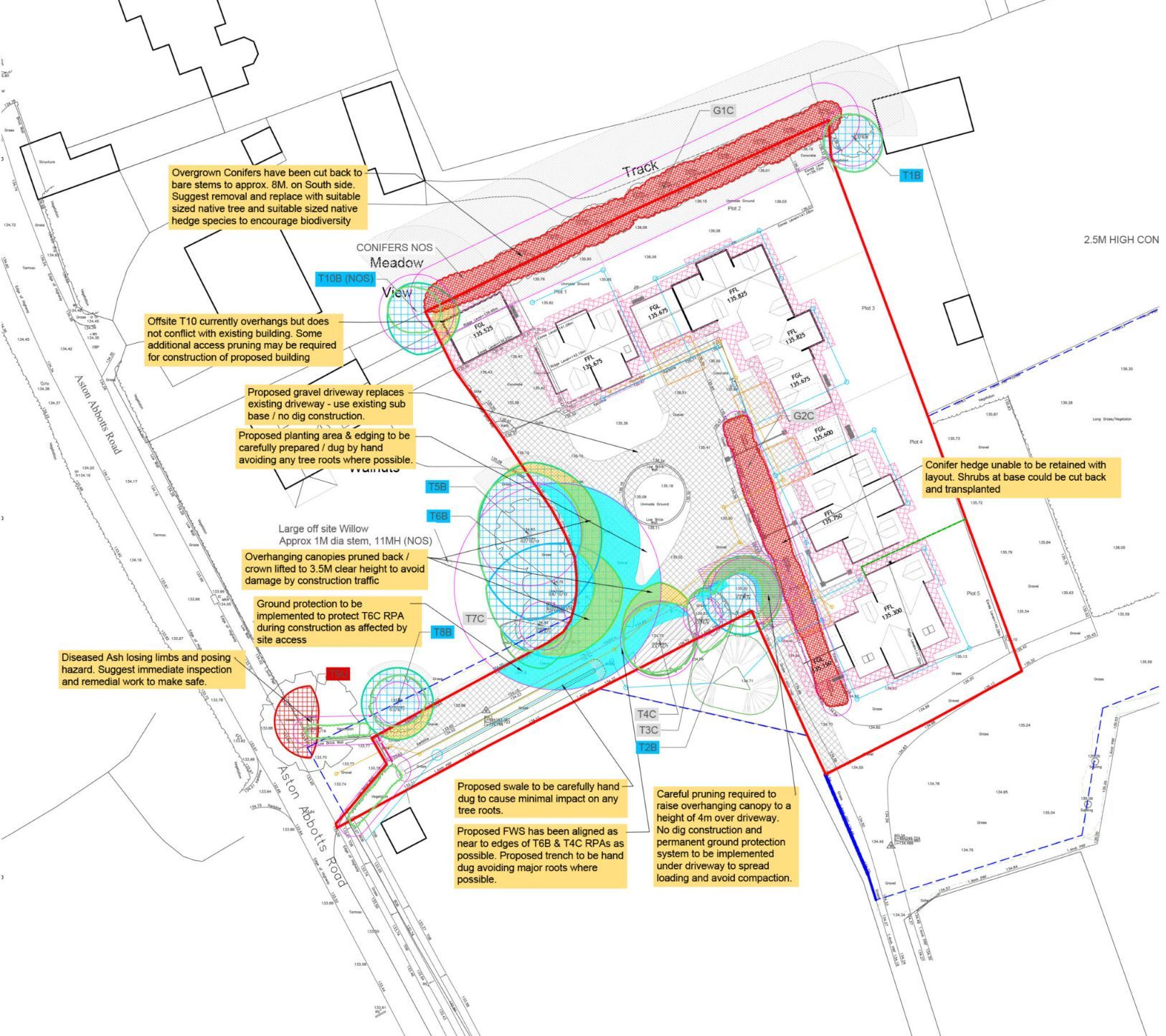
A BS:5837:2012 compliant tree survey is the initial step for assessing trees in relation to development and planning. Information gathered during the initial survey is used to create a Tree Constraints Plan and provide developers with initial advice in regards to arboricultural conflicts.
After an initial tree survey, developers might consider conducting a feasibility study to assess the likelihood of obtaining planning permission and to inform their purchasing decision. This study will offer a thorough assessment of the site's development potential, including a tree valuation and an estimate of the potential costs for necessary tree work, whether for preservation or safety. Urban Tree Management will carry out this study, enabling the creation of a realistic site plan that optimizes space utilization without the need to remove a significant number of trees, thereby enhancing the prospects of securing planning permission on the first attempt without onerous conditions. Understanding the size and location of trees will enable architects to integrate elements such as tree shade, locations for overhead and underground services, and other tree-related constraints into their designs.
The feasibility survey will measure tree heights, root protection areas, and crown spreads. Tree crown spreads will be gauged at the four cardinal points for precise plotting on a tree constraints plan. The survey will also offer advice on necessary health and safety tree work and classify trees as A, B, C, or R following British Standard BS5837:2012, indicating the amenity value of the trees and identifying those most deserving of retention and protection during development.
Detailed Aerial Surveys
Drone technology is revolutionizing the way we work, opening up new opportunities that once belonged in the realm of science fiction. The most apparent use for drones is in development sites, yet as landowners are increasingly urged to improve their environmental assets, they require a swift and cost-effective method to identify these opportunities.
Drones are invaluable during feasibility assessments, capturing site details that aid in conceptual design. Survey outputs can include long-distance images to contextualize a site within its broader landscape, orthorectified (high-resolution 2D) images, 3D models in point cloud or triangle mesh formats, video footage, or a combination thereof. The software and algorithms transforming photographic images into meaningful and usable data are continually advancing, ensuring that the potential of drones remains extensive and incredibly promising.
TO FIND OUT MORE ABOUT OUR OUR ARBORICULTURAL SERVICES, PLEASE BROWSE:


BS5837 Tree Surveys &
Feasibility Studies
If you need a professional tree survey to support your planning application, get in touch and we’ll send a free quote within 24 hours
Urban Tree Management operate throughout the Greater Manchester, Lancashire, Cheshire, Merseyside and Nationally for tree-related projects of all sizes.
Popular Tree Surveys
Arboricultural Impact Assessment
Arboricultural Method Statement
Tree inspection & Risk Assessment